NOAA chart for Delaware Bay

ddurand

Member
Member
Joined
Jun 20, 2001
RO Number
5015
Messages
837
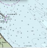
I will admit that I am not familiar with all the possible symbols on a NOAA chart and the charts that lists the NOAA symbols is 120 pages long. This is a snippet of the section leaving Cedar Creek in the Delaware Bay. Looks like I need to travel a narrow route then make a slight turn (avoiding submerged pilings) then a little more on a narrow route and I am out into the bay.

Questions, how will I know I am in this narrow route? When to make the slight turn and what do the two white squares mean? Will the submerged pilings be marked?

I have a chart plotter but the boat is new to me, as is the chart plotter and I would like to know ahead of time what is out there.
 

Attachments

  • chart1.jpg
    chart1.jpg
    85.6 KB · Views: 17
I guess we re supposed to guess what size bot and draft you have.

Here is the Aquamap version of the same area. Yes coming out you need to stay in the channel all the way to G1 and R2 then follow the recommended path almost due east to deeper water. There seems to be a submerged jetty on both side of the channel. If it is your first time coming out of there I highly suggest asking the marinas or fuel docks for information.

And go slow.

FEB5854A-E50C-4CA9-8765-D18BA17D7ABD.png
 
It's a 27' Chaparral with an I/O.

I was told by a to local who fishes to stay between the sets of pilings until they end then take a hard left.

How come my NOAA chart does not have the G1 & R2?
 
How come my NOAA chart does not have the G1 & R2?
it does

-edit to add:

The text descriptor reads, "FL R 25ft 6M "2"

ie: Flashing red lit marker 25ft/6 meters high, and labeled "2"

Similar for the other one...

It's only 134 pgs now... ;)

Oddly enough, most of the symbology and abbreviations are easy to "interpret", but this is a VERY compressed data exchange format, and understanding the abbreviation will greatly expand the usefulness of the data set.

I have been "reading" charts for decades, so I do not even notice that the info is "compressed". When I see on a chart "Fl R 25ft" I immediately look for the tower with a big placard and a red flashy thinghy on it. But you need to start somewhere.

But since most of the abbreviations are "logical", once you get it figured out, the pattern becomes intuitive and explains a great deal. It is rare that I need to consult "Chart No. 1", but it does, on occasion, happen.

Digital charts ( depending on the display software ) perform the translation for you ( if an item is selected ) but it provides little, if any addl info.

...and there is a very great deal of info displayed on every chart.


--------------------

Slightly off topic, but a comprehensive reference ( and free ) is:

The American Practical Navigator"


It includes charting, but there is a massive amount of "other" materiel as well. "A little light bedtime reading"

While studying and mastering all of the info would be a good thing, for most, it is not mandatory ( IMHO ) , But having "read through" and been exposed to the materiel would serve you well...
 
Last edited:
it does

-edit to add:

The text descriptor reads, "FL R 25ft 6M "2"

ie: Flashing red lit marker 25ft/6 meters high, and labeled "2"

Similar for the other one...

It's only 100 pgs now... ;)

Oddly enough, most of the symbology and abbreviations are easy to "interpret", but this is a VERY compressed data exchange format, and understanding the abbreviation will greatly expand the usefulness of the data set.

I have been "reading" charts for decades, so I do not even notice that the info is "compressed". When I see on a chart "Fl R 25ft" I immediately look for the tower with a big placard and a red flashy thinghy on it. But you need to start somewhere.

But since most of the abbreviations are "logical", once you get it figured out, the pattern becomes intuitive and explains a great deal. It is rare that I need to consult "Chart No. 1", but it does, on occasion, happen.

Digital charts ( depending on the display software ) perform the translation for you ( if an item is selected ) but it provides little, if any addl info.

...and there is a very great deal of info displayed on every chart.
Thanks. Learned something.
 
Thanks. Learned something.

For the "Fl R 4s 25ft 6M "2" ... The "M" does not refer to meters. It means the light has a nominal visual range of 6 nautical miles. It wouldn't be meters, as 25 feet is closer to 8 meters than 6 meters. Anyway, that light can be seen at a nominal distance of 6 nautical miles out.
 
Back
Top