GPS question

  • Thread starter Thread starter blouderback
  • Start date Start date
B

blouderback

Guest
So I have a little hand held GPS unit that I use on the boat. I know not to trust it too much, as sometimes the cheapo map overlay that came with it (and cannot be updated) is sometimes out of whack with reality. I've actually seen my path appear to run across the ground when boating in the Delaware River, and I was pretty sure I didn't actually leave the water.

My question is, if I saved a previous track that I knew to be good and in the channel, can I be reasonably sure that I can follow it back, maybe a few days later? I guess my question is, is it the GPS tracking that's off or the map overlay that's off?

I wouldn't want to trust my previous saved track if the GPS tracking could actually be off later in the day, possibly due to locking onto different satellites or other interference or something.
 
quote:

Originally posted by blouderback

I've actually seen my path appear to run across the ground when boating in the Delaware River, and I was pretty sure I didn't actually leave the water.


I had the same issue, and it turned out I was getting false info from my chartplotter...I have it fixed now...
 
IMO yes you can. I use a Garmin handheld and while the "map" really sucks, "repeatability" is good. Even with the NOAA charts, while ship channels and other "important" areas are well charted, less-used (and less important) areas can be off by some distance. However my "track" is right on, trip after trip after trip.

Next time you're out, "waypoint" some fixed aids (NOT buoys) and then come back to them later. Only then will you be able to trust (or not trust) the equipment. My experience is the GPS is probably good within 30' or so.
 
bread crumbs (previous tracks) are usually extremely reliable and if followed, assuming you zoom in very close, will let you really backtrack within feet.

the issue with appearing on land in some places is not a GPS issue, it's chart problem. charts can be inaccurate or the datum can be off. very rare in the US, but it can happen.
 
We often follow our breadcrumbs they are dead on, but I'm not using a hand held Bob. I did just recently purchase a small Monterey 206 and put a Garmin 545 in it and I am using the built in GPS antenna. The small GPS display seems as accurate as my larger plotters and network in the Mainship. I also interfaced the unit into a Standard Marine DSC VHF radio. It's nice to have something faster, cheap on fuel and fun.
Bill
 
I have a HH GPS and my bread crumb tracking is right on everytime. This is over 4 yrs........
 
simple excercize to see the accuracy of GPS nav: next time you're anchored, zoom in with your GPS to something like 100' scale and if your unit supports it, move the cursor to wherever you dropped the hook.

you will see teh breadcrumbs as you swing back and forth, as well as wind gusts since those arcs will be a little further out. the distance to cursor will also increase in a gust, by 5 to 10' as your rode lifts off the bottom then come back.
 
You guys seem to depend on GPS, that will get you in trouble in the end. Go with charts, use GPS as nice to know, maybe.
 
I think the first question is the GPS WAAS enabled. Those little handhelds I use as a backup to the backup. It will give you a position if youre sitting in a life raft.

We've heard stories of boaters hitting land when they fired up their auto pilot to enter a channel and then went below to get a drink.

If you are going to depend on electronics, spend the money and get a good one with the newest technology.

Also, what Jim P. Said. Get charts and know how to read them
 
Anyone who totally depend on GPS will eventually get in trouble. However I have found most charts are not up to speed either. You need to use common sense which includes a proper watch, use your depth finder, charts and compare them to your plotter when charting a course. Yes my plotters are WAAS enabled and I also use a KVH position sensor on the large boat. I also periodically check the Garmin website and download the latest software.
Bill
 
When all else fails stop the boat if safe to do so, get on the radio and ask for local help from SeaTow or US Boats. Forget the USCG they will not help unless there is a medical issue they don't want the liability. I also check the NTM's from the USCG on my NAVTEX receiver. I can also turn on the Class B AIS if I need the USCG to see where I am at and other boats that are equipped with either receivers or transponders like my unit. I am seeing more and more boats weekly using Class B AIS. When I 1st installed it I only saw Class A AIS vessels.
Bill
 
On the La. coast, no charts or GPS are up to date at this point. When fishing, I find places that was land 3 to 4 years
ago and it is just 1 to 1.5 ft. deep water now. The charts still show land there, but it is all water.
You have to know the area, if not, go slow. Unless you are offshore, miles out, but watch out for platforms, rigs and ships.
Coastal erosion is taking away land faster than NOAA can update charts in our areas. The closer to the GOM you are, the
more erosion is taking place.
You cannot believe any GPS or chart right now when going in an area for the first time. I do use my poopy trail for return
trips. It is good for night trips when used with the radar.
 
Some GPS units had a problem when one satelite was replaced last year. Most GPS manufacturers put up a firmware upgrade to fix thte problem so it might be woth checking if there is an upgrade available for your unit.
 
To get back to the original question, on a GPS, the breadcrumbs are generally very reliabel, the charts are not.
 
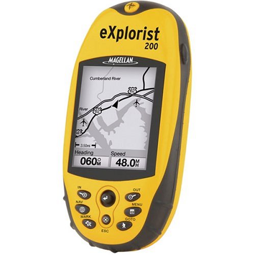
Thanks for all the replies. I certainly understand not trusting the electronics for everything. I have only trusted the bread crumbs I've left, and never trusted the map overlay that is included with the unit. Unfortunately, mine is so basic and cheap that there is no way to connect it to anything so that it can be updated. It's a little Magellan Explorist 200:

41ECD76QMWL._SS500_.jpg
 
Bob,

My suggestion would be to:

1. Drop some minor coin for an anchor.

2. Drop some minor coin for a mapping GPS (see Garmin GPSMAP 420)
 
Bob, Garmin's 545 is not expensive and well worth it. I am amazed at the displays images in direct sunlight. The depthfinder is nice and it is also set up to use an AIS transponder or receiver with it if needed. It's nice is easy to install and would make a great addition to any small boat, even a larger boat as a stand alone back up. You can upload new firmware to an SD card.
Bill
 
Bob:

RE: GPS accuracy

First you have three issues:

1) How accurate is the GPS system?

The system will always be within 100 meters ( even when Selective Availability is ON ). This can be improved through the use of WAAS or other similar methods.

2) How accurate is my particular unit?

All GPS units should perform equally well if they have the same satellites "in view". If your unit is WAAS enabled, and you have 3 or more satellites in view, you should get within 10 meters about 70% of the time. Better units have the ability to receive more satellites data continuously ( vs time sharing ) so the data from better units will be marginally more accurate than the most basic, inexpensive units.

3) How accurate is the base map?

:) I LOVE this one. In many areas, the base map, provided by your "gubber-mint", is not very accurate at all. Look at the "date of base data" blurb on a paper chart ( Jim Pend, take note. This applies to paper charts as well as electronic ). In some cases the land mass position goes back to the mid-to late 1800's. Though dredged channels ( esp those for large commercial vessels ) will be plotted very accurately, and sometimes more than once a year, most of the area on your chart is old, or very old data. As rduhon states, the map data for much of South Louisiana is just plan bad. I know that one local favorite recreational fishing area has sounding data from pre-Civil War soundings. Not that the position of those soundings is likely off by quite a bit, by modern standards.

--

Most GPSs should give excellent "repeatability", to the standards of the equipment used. ie: a cheap, non-WAAS unit will always be within 100 meters, and if WAAS enabled, should normally be expected to be within 10 meters.

Even the "included" GPS unit that comes with the software for you laptop will give you good locations, though the update rate might be horrid.
 
Geez some days some replies leaves one wondering what the blazes is going on!
 
Bob,
Here's how I use my GPS/Chartplotter. At the start of every season I clear out all the tracks from the year before; I take a high speed cruise through my area laying down a new track for the new season based on new buoys, any shoaling, etc. This track usually is good all year.
Hope this helps,
Perry
 
Back
Top