Unusual No Wake Buoys in Barnegat Bay

dominic

Member
exMember
Joined
Jan 1, 2000
RO Number
2355
Messages
731
I was out on the Barnegat Bay this past Sunday, just south of Toms River. The Pic below is a 'representative' of the ICW in the areas betwwen markers 36 through 39.

nowakebuoysBB.jpg


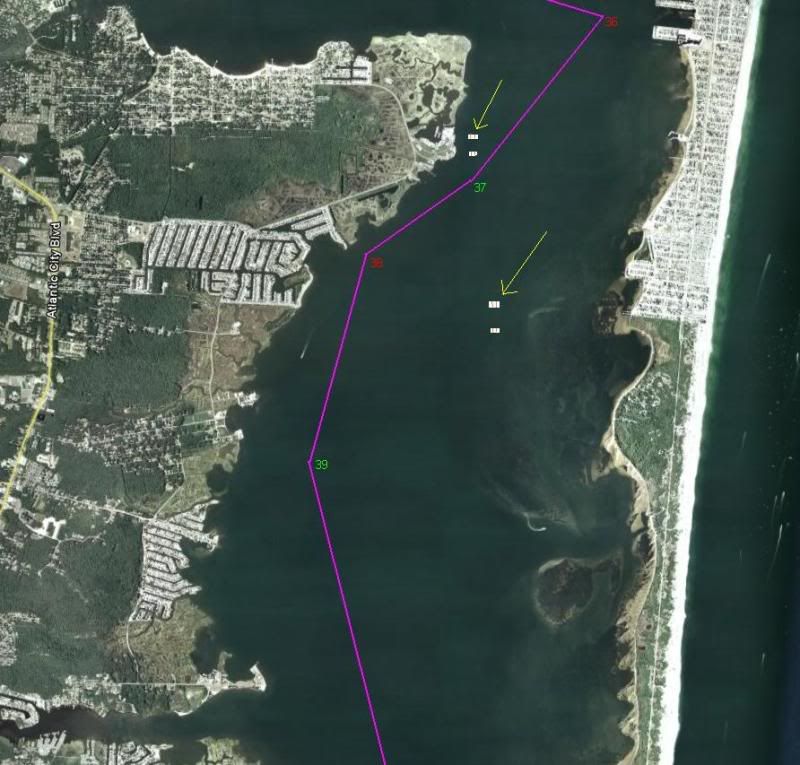
The Yellow lines are pointing at two sets of two No Wake barrels and the general area where I saw them. That is VERY unusual to see. A lot of times you will see big orange temporary barrels to mark off a 'sailboat race'. These, however, are official No Wake barrels.

I'm guessing some kind of research project? Rutgers maybe?

Does anyone know of anything going on? Are there more out there?
 
Have you checked the local notice to mariners? These sort of things should be listed there.
 
Dom,

I also saw the ones by B37. I saw the dredge barge out in that area, the same one from last year that cleaned up the run thru sedge islands to Barnegat Inlet. Maybe they more cleaning up to do there, but that doesnt make sense for the ones further south.

I'll have to use that as an excuse to use my new Typhoon inflatable this weekend.
 
I admit that I haven't been staying current with NTM's yet this season. I'd have to go back and read them to find when, if, it was reported. I was hoping to 'cheat' a bit and see if anyone else had been staying current.

I'll go back and look in the NTMs and report if I find anything....
 
This may explain the barrels north west of ICW 37...

NJ – BARNEGAT BAY – SHOALING
A shoaling area consisting of crushed clam shells has been reported near Goodluck Point in Barnegat Bay at approximate
position 39-55.500N, 074-06.109W. Chart: 12324 Ref. LNM 53/08.
 
I thought it was interesting how my chartplotter in Barnegat Bay showed now buoys at all.
SeaTow Captain said that due to shoaling they are not on any charts.
What do you guys do, visually mark them every season?
Seems every year your prior year tracks are worthless.
Interesting bay though, looked real nice from what I saw at 5knots with tears in my eyes from the bridge.
 
Dave:

The ICW markers should be on your chartplotter. The Daysticks....(those cedar sticks with red triangles and green squares with the bicyle relectors).....won't be on your chartplotter. Other locally marked channels with floating cans and nuns may or may not be on your chartplotter....mostly not as they are constantly re-arranged. The channel you came in from the Ocean through Barnegat inlet is called the Oyster Creek Channel....that channel is in constant flux and will not show up on your chartplotter.

If you come down this weekend with your wife, and the weather is right, we can head out to a local waterfront restaurant and I'll see if I can't convert you....if you come with Walt, I'll understand that you two may just want to be alone.... :)
 
Sounds good Dom.
I have a brand new Navionics Gold Chip and some day markers show as a little purple line.
What was odd was that in the BB area I was passing all these red and green buoys but saw none on the plotter, occasionally it would show some of the larger ones. So I guess those get moved around alot. Seem BB is alot like Moriches, you never can trust your chart and have to rely on your eyes and at my age, that can be risky!

Weather for Saturday looks iffy, but we will come no matter what. If Sunday is better and you want us to come then and do lunch we can. Would love to get a tour of the area on your beautifal SeaRay! I almost bought a 42 for sale a couple of years ago, but the wife really wanted a flybridge. I know complete opposite of your wife. I really like express boats better, it feels more like a boat to me. She loves the sliding glass door, living room thing. That is why the 4080 was a good compromise, its a low bridge, has speed, and looks a little express like.

I will see if I can talk Walt and his wife into taking another ride. I think he is sick of going to Jersey with me, would be his fourth trip! I am doing my part to support Jersey's economy and EZPass on the GSP!
 
quote:

Originally posted by dominic

This may explain the barrels north west of ICW 37...

NJ – BARNEGAT BAY – SHOALING
A shoaling area consisting of crushed clam shells has been reported near Goodluck Point in Barnegat Bay at approximate
position 39-55.500N, 074-06.109W. Chart: 12324 Ref. LNM 53/08.


There is a research project going on where they are trying to re-establish clam population in certain areas of the bay and they are laying a bed of crushed clam shells. This may be one of them.

I thought they were going to put it more in the river, as the last location that there were commercial clam harvests were off of Ocean Gate Yacht Basin (at least natural clams this far north)
 
From this morning Asbury Park Press, this may have something to do with the no wake barrells....

http://app.com/article/20090430/NEWS02/904300431/1070/NEWS02

Barnegat Bay dredging funds approved as part of stimulus package
Feds fail to include beach replenishment projects
By NICHOLAS HUBA • MANAHAWKIN BUREAU • April 30, 2009

Money to dredge Barnegat Bay has been approved as part of the federally funded stimulus package, but funds for additional beach replenishment projects — such as erosion studies and long-term nourishment efforts — were not included.

The state has received approximately $2 million in funding for maintenance work across South Jersey and the Shore area.

"During these tough economic times, it is disappointing that these important recovery funds will not be going toward beach replenishment projects, which are critical to our shore communities," said Rep. John Adler, D-N.J. "But I am pleased to see nearly 2 million dollars directed to protect the New Jersey Intracoastal Waterway and Barnegat Bay."

Army Corps of Engineers officials have said that not receiving funds from the stimulus package will not impact currently planned projects, such as the pending beach replenishment project in Harvey Cedars.

The projects that will receive funding through the stimulus package include:

$1.26 million for maintenance dredging of the remaining critical shoal areas within the New Jersey Intracoastal Waterway.

$350,000 for maintenance dredging to protect Barnegat Bay.

$300,000 will be used to prepare a regional systems-type study for the coast of New Jersey; develop a regional sediment budget and an improved understanding of regional coastal processes; and implement an efficient regional sediment management and monitoring program to reduce long-term nourishment costs.

Adler has been critical of the administration removing the funding for beach replenishments projects from the stimulus package. In late March, Alder sent a letter to Peter Orszag, director of the White House Office of Management and Budget, asking him to leave the money.

"On behalf of my constituents in Ocean County, I urge you to maintain funding for beach nourishment projects," Adler stated in the letter to Orszag. "The money included in the American Recovery and Reinvestment Act is necessary to conduct beach erosion studies, build groins and jetties to protect beaches from surf, storm surge and tidal currents, and long-term nourishment efforts like pumping tons of dredged sand back onto eroded beaches."
 
Seems like a drop in the bucket to what's really needed to maintain and improve the ICW. Better than nothing I guess.
 
They recently installed an "upweller" on the Wildwood Ave pier in Ocean Gate. It is essentially a tank with clam and oyster shells in it with running water. I believe this particular tank is for raising oysters that will eventually be replanted in between the no wake markers

I believe there are a few more of these upwellers around the bay. I think one is at the Mantoloking Yacht Club and there is a plan to put one at Ocean Gate Yacht Club.
 
Dominic,
Those barrels actually say "low water" not "no wake" and yes they are new this year. I always used to cut through the area close to the shore and never had issues with depth there. Now I stay just outside them.
 
Back
Top